

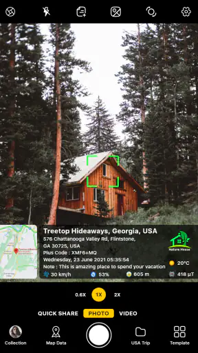
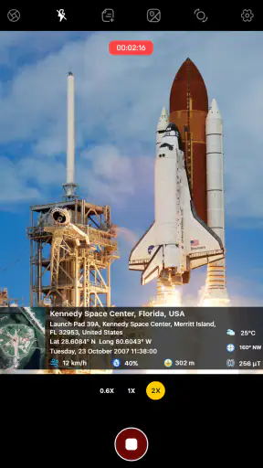
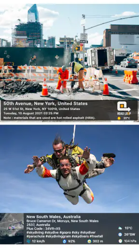
I noticed the appeal of GPS Map Camera almost immediately: it turns a normal phone photo into a small piece of evidence about where and when it was taken. Instead of relying on memory, a separate map application, or a handwritten note, I can keep location details visible on the image itself. That makes it more practical than a standard camera for certain jobs, even though it is not designed to replace a full-featured photography app.
Developed by GPS Map Camera, this free photography app is aimed at people who need location, address, and time information attached to their pictures. Its audience is broader than hikers and geocachers. I can see it being useful for documenting work progress, recording travel stops, checking property conditions, or keeping a visual log of outdoor activities. It is available for Everyone, supports devices running Android 6.0 or later, and has reached over 100 million installs. Those figures suggest that the idea is easy to understand, even if the execution will not suit every photographer.
Why the first week feels useful
During the first few uses, the main benefit is wonderfully direct. I open the camera, frame a subject, and get an image that carries context along with it. A regular photo might show a damaged fence, a trail marker, or a campsite, but the stamped information helps answer the questions that usually come later: where was this, and when did I take it?
That difference matters most when I am taking several similar pictures. A series of building inspections can quickly become confusing when the images look alike. A location and timestamp displayed on each one make the collection easier to sort visually. I do not have to depend entirely on filenames, a separate notes app, or the photo library's map view.
The app also has a clear advantage over simply photographing a map screen and then taking a separate picture. The location information is placed into the captured image as part of the camera workflow, so the result is easier to share with someone who may not use the same mapping tools. That is particularly handy when sending a quick update to a colleague or keeping a record for myself.
For a realistic everyday example, imagine checking several rental properties in one afternoon. I can photograph a gate, a wall, a meter, or a repair issue at each address. Later, the visible address and time reduce the chance of mixing up the pictures. It is not a replacement for a formal inspection system, but for a lightweight personal record, that extra context can save a surprising amount of sorting.
The first-week appeal is also helped by the app's narrow purpose. I do not have to learn a complicated editing suite before getting value from it. The important decision is usually whether the location details should appear on the finished picture. That simplicity makes it approachable for someone who wants documentation rather than artistic control.
What makes the stamped image different
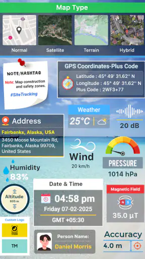
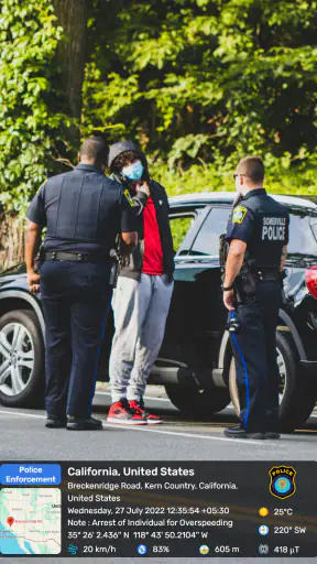
A normal camera keeps location information in metadata when the phone and camera settings support it, but that information is often hidden unless I open a photo manager or inspect the file. GPS Map Camera brings the details into view. This is the central trade-off: the image becomes more self-explanatory, but the overlay can also become part of the visual composition.
I would use the app when the destination of the image benefits from visible proof or context. I would not automatically use it for every holiday photograph. A scenic image can look less clean when an address, map element, or timestamp competes with the subject. The best results come from deciding before shooting whether the picture is a record or a keepsake.
That distinction is one of the most useful habits to establish early. I keep the location-stamped camera for evidence, reference, and field notes, while using a conventional camera for portraits, food, family moments, and images I may want to print. Treating it as a documentation tool rather than a universal camera prevents disappointment.
There is also a practical privacy question. A visible address or precise location can be helpful when sharing a work record, but it may be inappropriate for a public social post or a picture taken near home. I would review the overlay before sending an image outside its intended audience. The same feature that adds credibility to a site report can reveal more information than I meant to publish.
Useful workflows beyond casual travel
One less obvious use is creating a visual trail of temporary conditions. If I am waiting for a delivery, monitoring outdoor equipment, or checking a garden after bad weather, repeated location-stamped images can create a simple chronological record. The app does not need to become a complex project-management tool; it can simply provide consistent context whenever I take the picture.
Another useful workflow is pairing the image with a short note outside the app. I can photograph the subject with the location visible, then add a brief explanation in my preferred notes or messaging tool. This is more reliable than expecting the picture alone to explain why it matters. The image establishes place and time, while the note captures the action needed.
For hiking or geocaching, I find the visible coordinates more useful at the moment of sharing than during navigation itself. I would still rely on a dedicated map or navigation tool for route planning and safety. This camera is strongest at recording a point after I reach it, not at replacing the broader planning and orientation features of a specialist outdoor application.
People who manage repeated visits can also benefit from a consistent shooting routine. Photograph the same feature from a similar angle, keep the overlay readable, and avoid taking a large number of nearly identical pictures without a purpose. The app gives each image context, but it cannot decide which view will be most useful later. A little discipline makes the resulting archive much easier to understand.
What remains valuable after the novelty fades
The novelty of seeing a map or address on a photo wears off fairly quickly. The lasting value depends on whether I regularly have a reason to prove where an image was taken. For someone who visits sites, travels through unfamiliar areas, or records outdoor work, that reason can be recurring rather than occasional. In those cases, the app earns a place in the routine because it removes a repeated step from documentation.
For a casual photographer, the long-term case is weaker. If most pictures are intended for albums or social feeds, visible location details may feel like clutter. A standard phone camera is faster for spontaneous shots, and its gallery tools are usually better suited to organizing personal memories. I would not keep GPS Map Camera as my only camera unless location stamping was central to my daily use.
The app's average rating is 3.5 from around 376 thousand ratings, which gives me a useful expectation: the concept has broad reach, but the experience is not universally effortless. I read that as a reason to judge it by the specific job I need done rather than by popularity alone. A focused tool can be worthwhile for a narrow workflow even when it is not the best general camera.
Its free entry point makes experimenting easy. I can find out whether the overlay fits my work or travel habits without committing money first. There are in-app purchases ranging from $2.99 to $17.99 per item, so I would spend time with the basic experience before deciding whether any paid option solves a real recurring problem. The important question is not whether extra controls sound attractive, but whether they reduce friction in the way I actually take and share photos.
Routine matters more than features
After the first month, the strongest benefit is consistency. If I always use the app for site visits, the images become a dependable record instead of a collection of occasional experiments. That consistency is more valuable than the initial visual novelty. I can compare pictures taken on different days with less uncertainty about their context.
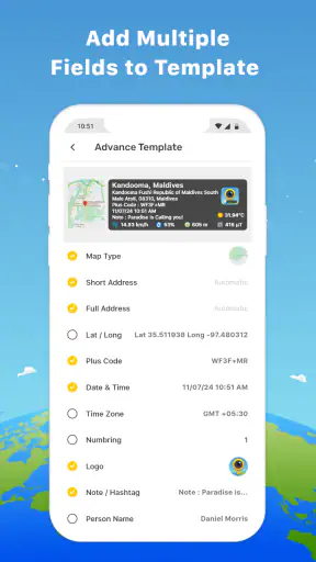
There is a trade-off between detail and readability. A crowded overlay may preserve more information, but it can cover part of the subject or make the image harder to scan. I prefer to frame the important object with some spare space, rather than placing the key detail directly under the text. This small adjustment is easy to overlook and makes a bigger difference than changing the camera for every shot.
I also recommend checking the result immediately after taking an important picture. A quick review can catch an unreadable stamp, an accidental obstruction, or a composition that does not show the condition clearly. This is especially important when the image is being used as a record. A location label alone does not make a weak photograph useful.
When sharing images, I think about the recipient's needs. A client or teammate may appreciate a visible address and time, while a friend may prefer a clean picture. Sending the stamped version to the first audience and a regular camera image to the second is often the better habit. The app is most effective when I treat the overlay as communication, not decoration.
The maintenance burden is small, but real
GPS Map Camera is not maintenance-free simply because it is straightforward. Its usefulness depends on location information being available and accurate enough for the task. Before an important visit, I would check that the phone can determine its position and that the displayed details are readable. Waiting until the moment of the shot is a poor time to discover that the context is missing or unsuitable.
Storage management is another recurring consideration. Documentation workflows can produce many images, especially when I photograph several points at one location. The visible stamp helps me identify the files, but it does not remove the need to delete duplicates, archive completed work, or organize pictures into folders. If I keep everything indefinitely, the convenience turns into a clutter problem.
The app should also be kept separate from my privacy habits. Before exporting or posting a picture, I inspect what the overlay reveals. A photograph of a valuable item, a child's activity, or a private property can unintentionally disclose a precise place and time. I would create a simple rule: stamped images stay with the people who need the record, and clean images are used for wider sharing unless the location is intentionally public.
Version 1.9.34 is the current version, and the app was released on March 29, 2020. I do not treat version numbers as a guarantee of a perfect experience, but they help place the product in context: this is an established tool rather than a brand-new experiment. Its continued usefulness still depends on whether the interface and location workflow fit my phone and habits.
Where fatigue starts to appear
The first source of fatigue is visual repetition. If every image carries the same prominent information, the collection can begin to feel mechanical. That is acceptable for inspections and logs, but tiring for travel photography. I would avoid using the stamped camera for an entire day unless the trip itself is being documented as a route or field record.
The second is the extra decision before every shot. I have to ask whether the overlay should be visible, whether the frame leaves room for it, and whether the image is safe to share. Those decisions are reasonable for important records, but they make the app less appealing for quick, unplanned photography. A regular camera wins whenever speed and clean composition matter more than context.
There is also a risk of false confidence. A photo with coordinates and a timestamp looks authoritative, but it still needs a clear subject, sensible framing, and honest interpretation. The stamp can tell me where and when I took the picture; it cannot prove what happened outside the frame or guarantee that the photographed condition has not changed. I use it as supporting documentation, not as a substitute for a complete report.
Compared with a dedicated mapping application, this tool is lighter and more immediate for capturing a visual record, but it is not the better choice for navigation. Compared with a standard camera, it offers stronger visible context but less freedom when I want an uncluttered image. Compared with a professional inspection platform, it is easier to start but less suited to structured records, assignments, or team-wide processes. Those comparisons make its proper place clear: it is a focused middle ground.
Who should keep it installed?
I would recommend it to hikers who want a visible record of notable points, people doing occasional property or maintenance checks, travelers who want location-rich memories, and anyone who repeatedly sends photos where place and time matter. It is also a sensible backup for a small business owner who needs quick, understandable site documentation without adopting a larger system.
I would suggest skipping it if I mainly take portraits, family snapshots, food pictures, or polished travel scenes. Those users may find the overlay distracting and the separate camera workflow unnecessary. Someone who needs advanced editing, professional color control, or a formal inspection database should also look elsewhere. This app solves a specific documentation problem; it does not try to be an all-purpose creative studio.
For me, the lasting test is simple: after the novelty disappears, do I still avoid a repeated problem by using it? When the answer is yes, the app has recurring value. When the answer is no, a normal camera and a well-organized gallery are less demanding.
My final opinion is positive but deliberately narrow. GPS Map Camera earns lasting space when visible location context is part of the job, not merely an interesting effect. It is free to try, accessible on older Android devices, and focused enough to become a dependable habit for the right user. I appreciate how quickly it turns a picture into a more informative record, but I would not use it for every photograph or assume its stamp replaces careful documentation.
After the first week, the question is whether I have a repeating use case. After a month, it is whether the images are genuinely easier to identify, share, or review. If both answers are yes, this small photography tool can remain useful long after its novelty fades. If not, keeping it installed may only add another camera icon and another source of visual clutter.
With 100M+ installs and 387 reviews shown alongside its store presence, the app clearly reaches a large audience, while its 3.5 average suggests that expectations should stay realistic. I would recommend trying it for one complete workflow—such as a property visit, trail record, or work log—before paying for anything. That test reveals more than the first impressive stamped image: it shows whether the app actually saves time in the routine I care about.


